(From this)
This summer, Tel Aviv University’s Sonia and Marco Nadler Institute of Archaeology is adding another excavation to their already expansive list of seven active digs. Azekah, a city of the ancient kingdom of Judah that features prominently in the Bible — both as a main border city and the fortification which towers above the Ellah valley — is the site of the legendary battle between David and giant Goliath. The new dig will be led by TAU’s Prof. Oded Lipschits, Dr. Yuval Gadot, and Prof. Manfred Oeming from Heidelberg University, Germany.
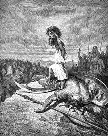 |
| A drawing of the battle |
The Assyrian king Sennacherib described Azekah as “an eagle’s nest … with towers that project to the sky like swords.” The Judahite stronghold bordered the land of the Philistines and was strategically positioned for military action and trade. This culturally significant city could hold the answer to historically significant riddles about the development of the Kingdom of Judah, the relationship between Judah and its neighbors, and the Judahite culture.
The dig’s first season will run from July 15 – August 24, 2012. Registration is now open to volunteers for the first season of what the directors call a truly international dig, with partner universities from all over the world. “In every square that we are excavating, there will be participants from all over the world,” says Dr. Gadot. “It’s a great way to get to know new people and gain valuable experience.” More details about the new dig are available at www.azekah.com.
Beneath the layers of destruction
After years of excavation at Ramat Rahel near Jerusalem, the heart of the Kingdom of Judah, the researchers are looking to Azekah for insight into what life was like on the periphery of that ancient kingdom. “We are asking questions about the history of Judah from the westernmost border,” says Prof. Lipschits, noting that the main Philistine Kingdom of Gat was located just a few kilometres to the west of Azekah. The site probably served as the setting for the tale of David and Goliath, the story of an unlikely Judahite hero who overcame the Philistine’s champion warrior, because Azikah was truly “a meeting point of the two different cultures,” he explains.
Beyond its cultural significance, Azekah was also a gateway to the Judahite kingdom, positioned along the main roads leading from the coastal plains to the Judean Hills at the heart of the kingdom. Although the city flourished for millennia, its natural riches and strategic position made it an inviting target for foreign powers.
The researchers hope that extraordinary findings await them beneath the destruction layers of the city, which was conquered in 701 B.C.E. by the Assyrians and in 586 B.C.E. by the Babylonians. When a site is abandoned, the people who once lived there would usually collect their gatherings and move on. But this wasn’t possible in the wake of a sudden and catastrophic event, such as war, says Dr. Gadot. Under the destruction layer, cultural artefacts are well-preserved, and there could also be remnants of an invasion, like a siege ramp, like the one that was found in the Judahite city of Lachich.
400 Million Year Old Machine discovered ?

An artifact 400 million years old has been discovered. The world’s first mechanical device!
In the remote Kamchatka peninsula (map below), 150
miles from Tigil, Russia, University of St. Petersburg archaeologists
discovered a strange fossil. The authenticity of the find has been
certified. According archaeologist Yuri Golubev, the discovery surprised
scientists. It was a machine.
After analysis, it seems that it was made of metal parts that seem to form a mechanism, a gear which may be of a type of watch or computer. The pieces were all dated – 400 million years ago!

Scientists said hikers found these remains in
rock. The archaeologists went to the place and made the discovery.
Hundreds of toothed cylinders made up the machine.They were in perfect
state of conservation. Archaeologists had to control the area, because
the people began to appear in large numbers to look at it. American
geologists examined the machine and confirmed it was a machine. They
wer amazed. .
Nobody could believe that 400 million years ago could have existed on
Earth even a man [even more a machine]. At that time, the forms of life
were very simple, but the finding suggests the existence of intelligent
beings capable of such technology. Certainly, such beings would had
come from other planets.
A History of Prosthetics in Pictures:
The BBC has made an interesting slideshow of prosthetics of the ages, even from the Roman era! I recommend a look. In pictures: Prosthetics through time
New Research shows Ancient Mayan Women were Powerful:
(Quoted from this article)
To cell phone-toting, internet-obsessed citizens of the modern world, ancient cultures may seem difficult to relate to. But a new look at Maya art and artifacts shows one of the most advanced ancient societies allowed women much more contemporary power than previously believed.
“I think the popular belief is that they were restricted to the private household,” said Shankari Patel, an anthropology graduate student at the University of California-Riverside. “The popular belief would be that women stay at home, they didn’t really participate in the rituals that were very important in Maya society. The previous research I looked at left out women completely.”
 |
| A female Mayan statue |
Patel studied artifacts at the British Museum that were brought to the U.K. from Cozumel, Mexico in the 1800s. She found spindle whorls, which were used by Maya women to weave cloth, and she thought it was curious that something apparently meant for private use was so elaborately decorated. With further research she was able to conclude that the spindle whorls were used in public Maya rituals as a symbol of feminine identity.
“Patriarchy in the past is very different,” she said. “Women controlled their own reproductive rights. They had women healers and women midwifes.”
Patel said that because many of the Maya sites were excavated by men, many of their questions about the ancient civilization weren’t related to women. She looked at iconography on art and pottery that showed evidence of female rulers and deities and read historical documents written by the Mayas that detailed their way of life.
The Spanish expedition in the 1500s led by Hernán Cortés saw the destruction of the Maya way of life and the collapse of its society, which developed from about 250 A.D.
“The first person [the Spanish] met was a woman,” Patel said, “The first thing they thought was, ‘What kind of a woman would leave a woman to make first contact?’ They refused to talk with her, so a man had to come and deal with them.”Thomas Patterson, a professor of anthropology at UC-Riverside and Patel’s dissertation advisor, said part of the reason women’s role in Maya culture has been lost for so long is that archaeologists have been too focused on the bigger sites. Now that that’s changing, researchers are learning more.
“These sites were all viewed as being built by men, viewed by men, and female deities were just weird,” Patterson said. “We didn’t know what to do with those. I think it gives us a much more textured understanding of the role of women in Maya society.”Cynthia Robin, a professor of anthropology at Northwestern University, called Patel’s research a “very significant finding” and stressed the importance of looking at history to inform the present.
“One of the things we know about Maya society is before the Spanish conquest there was no glass ceiling for women as there appears to be in our own society,” she said.Robin said that in Maya culture, women were heads of state as well as war lords.
“One of the great things about archaeological research is that it can show us how different life was in the past and how it is in the future,” she said. “So if we assume that gender relations were always the same then we’re just kind of justifying the inequalities that exist today.”Tools may have been First Form of Currency:
Hand axes, small handheld stone tools used by ancient humans, could have served as the first commodity in the human world thanks to their durability and utility.
The axes may have been traded between human groups and would have served as a social cue to others, Mimi Lam, a researcher from the University of British Columbia, suggested in her talk at the American Association for the Advancement of Science annual meeting here on Feb. 18.
"The Acheulean hand ax was standardized and shaped, became exchanged in social networks and took on a symbolic meaning," Lam said. "My suggestion was that hand axes were the first commodity: A marketable good or service that has value and is used as an item for exchange."
"Humans are unique in their use of tools," Lam said. "We make stone tools and the stones are durable and become part of our external environment." These tools, she added, could have been passed down in family groups or traded with other ancient hominids.
As humans became more intelligent, their tools become more symmetrical. "They became standardized as a result of social norms and also utility. Eventually, over time, hand axes were made special to set them apart," Lam said. "There was a trend to distinguish these common tools that had a standard shape."Examples of hand axes from about 250,000 to 700,000 years ago contain some of these special properties, such as being made of pink rock or rock embedded with fossils. Ancient humans also made large axes that stood out from the crowd.
More information here.
Unearthing Sussita:
 |
| Sussita Mountain |
Peering up from the shore of Lake Kinneret, known to many as the Sea of Galilee, one can hardly detect any structures atop that imposing flat-topped mountain. But at its summit, twelve years of continuous archaeological excavations on the site of the ancient city of Antiochia Hippos, now known as Sussita, have unearthed a wealth of Hellenistic, Roman, Byzantine and Umayyad structures erected during a period of a thousand years – from the 2nd century BCE to the 8th century CE. Yet much excavation work still has to be done to reveal the city in all its former magnificence and glory.
Sussita Mountain, on which Hippos was built, is situated between the Kinneret Valley and the southwestern Golan mountain range, about 2km to the east of the lake and rising 350m above it. Its strategic location near the eastern bank of the lake, the natural protection provided by the mountain, and the fertile fields of the lakeside districts, were most probably the features that attracted the Seleucid rulers in the mid-2nd century BCE to found a Hellenistic city here on the mountain crest.
The diamond-shaped table top of Sussita Mountain is about 600m in length from east to west and 250m from north to south. The fairly flat surface of this mountain plateau slopes down gradually from east to west. The upper layers of the mountain are covered with basalt, under which there is a soft limestone layer. These were the raw materials utilized for most of the ancient construction work.
It is clear that the mountain's relative isolation played a salient role in the decision by the Seleucids to build here. A fairly steep slope on the western side and deep and impassable gorges along its northern and southern sides severed the mountain from the surrounding terrain, leaving only a narrow saddle ridge on the east to link it with the southwestern slopes of the Golan Heights.
Along this ridge ran the main road to the city which was enclosed by a solid wall (about 1,350m long) with two gates. The main gate on the east faced the saddle ridge and the gate on the west led downwards along a winding, snake-like road to the shores of the lake and cultivated fields.
 |
| The excavated ruins |
From the beginning of the 2nd century BCE, the land that contains present-day Israel was ruled by the powerful Seleucid kings, rulers of a Greek-Macedonian kingdom that was created from the eastern conquests of Alexander the Great. In order to strengthen their hold on the various regions under their imperial rule, they founded new cities to contain a Greek-speaking and Hellenized Syro-Phoenician population that regarded itself as the bearers of Greek culture. From its very inception, Hippos (which means ‘horse’ in Greek) was a polis in all respects.
When the Romans assumed control over the eastern seaboard of the Mediterranean (from 63 BCE onwards), Hippos became one of the ten cities – the Decapolis – that comprised a particular settlement group which included, among others, Gadara (today Umm Qais in the Kingdom of Jordan) as its southern neighbor, and Scythopolis (today Beth Shean in Israel) to the southeast, on the western bank of the River Jordan.
These cities were highly influential centers of Greek culture within a region almost entirely populated by people of Semitic origin. The hostility between a gentile Hippos and a Jewish Tiberias on the opposite side of Lake Kinneret was notorious in ancient times.
During the Pax Romana that extended from the end of the 1st century BCE until the end of the 2nd century CE, Hippos enjoyed a long period of florescence and prosperity. Most of the magnificent public buildings, still in evidence today in their ruined state, were erected in the city during that time, such as the forum, basilica, kalybe, temple, odeion, and perhaps many others that are still to be discovered.
The Christianization of the Roman Empire in the 4th century CE did not bypass Hippos. The eight churches built there during the Byzantine period (4th to 7th century) are clear proof of the conversion of Hippos and its citizens to Christianity. The Arab conquest in the first half of the 7th century was not inimical toward the Hippos population, which continued to conduct their lives normally. Among the ruins in Hippos are a few structures and agricultural installations built during the Umayyad period.
But on January 18, 749 CE, the region suffered a violent and devastating earthquake. The damage it caused Hippos was so severe that all its citizens abandoned it, never to return. The dramatic evidence of the violent destruction can still be seen in the ruins today.
At the end of the First World War (1918), when the British and French marked the borderlines between the Palestine under the British Mandate and Syria under the French Mandate, Sussita Mountain was included within the mandatory borders of Palestine.
(More here)
And this post's star article is:


No comments:
Post a Comment