Primary Documents:
Saturday, 28 July 2012
Explain to Me: British Mandate of Palestine
This video is designed for people who are completely new to the topic and it is extremely brief so mind you, there are loads of stuff that aren't in it. Use this video as a start-up point for reading about Palestine.
(From David Charles)
Primary Documents:
Primary Documents:
Friday, 20 July 2012
Freshen Up With Archaeology Friday (Post IX)
Tonnes of news over the past week, here are the highlights.
Three Kingdoms' Tomb Holding Warrior Discovered:
About 1,800 years ago, at a time when China was breaking apart into three warring kingdoms, a warrior was laid to rest.
Buried in a tomb with domed roofs, along with his wife, he was about 45
years old when he died. Their skeletal remains were found inside two
wooden coffins that had rotted away. Archaeologists don't know their
names but, based on the tomb design and grave goods, they believe he was a general who had served one or more of the country's warring lords, perhaps Cao Cao and his son Cao Pi.
His tomb was discovered in Xiangyang, a city that, in the time of the Three Kingdoms, was of great strategic importance. Rescue excavations started in October 2008 and now the discovery is detailed in the most recent edition of the journal Chinese Archaeology. (The report had appeared earlier, in Chinese, in the journal Wenwu.)
Live-Science covers the issue well, here.
Largest Ancient Dam Built by Maya in Central America:
(Source)
Recent excavations, sediment coring and mapping by a multi-university team led by the University of Cincinnati at the pre-Columbian city of Tikal, a paramount urban center of the ancient Maya, have identified new landscaping and engineering feats, including the largest ancient dam built by the Maya of Central America.
That dam -- constructed from cut stone, rubble and earth -- stretched more than 260 feet in length, stood about 33 feet high and held about 20 million gallons of water in a human-made reservoir.
These findings on ancient Maya water and land-use systems at Tikal, located in northern Guatemala, are scheduled to appear this week in the Proceedings of the National Academy of Sciences (PNAS) in an article titled "Water and Sustainable Land Use at the Ancient Tropical City of Tikal, Guatemala." The research sheds new light on how the Maya conserved and used their natural resources to support a populous, highly complex society for over 1,500 years despite environmental challenges, including periodic drought.
The paper is authored by Vernon Scarborough, UC professor of anthropology; Nicholas Dunning, UC professor of geography; archaeologist Kenneth Tankersley, UC assistant professor of anthropology; Christopher Carr, UC doctoral student in geography; Eric Weaver, UC doctoral student in geography; Liwy Grazioso of the Universidad de San Carlos de Guatemala; Brian Lane, former UC master's student in anthropology now pursuing doctoral studies at the University of Hawaii; John Jones, associate professor of anthropology, Washington State University; Palma Buttles, technical staff senior member, SEI Carnegie Mellon University; Fred Valdez, professor of anthropology, University of Texas-Austin; and David Lentz, UC professor of biology.
Starting in 2009, the UC team was the first North American group permitted to work at the Tikal site core in more than 40 years.
Detailed in the latest findings by the UC-led efforts are
The BBC radio launched a three-part podcast of Persian history presented by

The portraits painted on to panels that covered the heads of mummies form part of an exhibition at the city's John Rylands Library. The panels, which have rarely been shown in public, were bequeathed to Manchester Museum by cotton magnate Jesse Haworth in 1921.
Petrie's excavations were funded by Haworth and many of his finds went on to form part of Haworth's private Egyptology collection. Mr Price said the institution was "incredibly excited" to be showing the portraits.
Papyri containing extracts of the apocryphal Gospel of Mary, the original of which has been credited by some to Mary Magdalene, and census documents are also on show.
The papyri were collected by John Rylands Library founder Enriqueta Rylands in the early years of the 20th Century.
Exhibition co-curator Professor Kate Cooper said the papers showed "a forgotten side of history".
"For example, the Gospel of Mary fragment argues that women should have a leadership role in the Christian church, a view which the medieval Church tried to suppress," she said.
Golden medallions from Romen era found in Bulgaria:
Scientists claim that they might have found the skeleton of the woman who posed for Leonardo Da Vinci’s most famous painting. Most art historians agree that Lisa del Giocondo was the woman who inspired Da Vinci to create his iconic work.
Now the archaeologists working in Florence are pretty convinced they have found the remains of the lady, merchant Francesco del Giocondo’s wife Lisa Gherardini.
The skeleton was unearthed beneath the medieval Convent of Saint Ursula in Florence. Knowing she became a nun after her husband died and lived in the convent until her death in 1542, a team of archaeologists began excavation works at the abandoned convent last year.
A female skull along with other fragments of human bones will undergo DNA analysis and compared with the DNA data in the bones of the Lisa Gherardini’s children to establish the truth. If the scientists confirm the DNA belongs to Lisa Gherardini, then specialists will try to reconstruct her face and try to solve the mystery of her smile.
(Source)
The Great Wall of China is already the longest man-made structure in the world but we may have to start calling it the Greater Wall of China.
A five-year archaeological survey done by the State Administration of Cultural Heritage (SACH) found that the total length of the Great Wall was 13,170 miles long and reached across 15 provinces.
This is more than twice the length previously thought. In 2009, SACH reported that the wall was 5,500 miles and stretched across 10 provinces.
Article of the Week: How did Persian and Other Western Medical Knowledge Move East, and Chinese West? A Look at the Role of Rashīd al-Dīn and Others:
Written by Paul D. Buell, a professor at the Western Washington University.
Three Kingdoms' Tomb Holding Warrior Discovered:
About 1,800 years ago, at a time when China was breaking apart into three warring kingdoms, a warrior was laid to rest.
 |
| The tomb (photo from Chinese Archaeology) |
His tomb was discovered in Xiangyang, a city that, in the time of the Three Kingdoms, was of great strategic importance. Rescue excavations started in October 2008 and now the discovery is detailed in the most recent edition of the journal Chinese Archaeology. (The report had appeared earlier, in Chinese, in the journal Wenwu.)
Live-Science covers the issue well, here.
Largest Ancient Dam Built by Maya in Central America:
(Source)
 |
| The dam (photo from the University of Cincinnati researchers) |
That dam -- constructed from cut stone, rubble and earth -- stretched more than 260 feet in length, stood about 33 feet high and held about 20 million gallons of water in a human-made reservoir.
These findings on ancient Maya water and land-use systems at Tikal, located in northern Guatemala, are scheduled to appear this week in the Proceedings of the National Academy of Sciences (PNAS) in an article titled "Water and Sustainable Land Use at the Ancient Tropical City of Tikal, Guatemala." The research sheds new light on how the Maya conserved and used their natural resources to support a populous, highly complex society for over 1,500 years despite environmental challenges, including periodic drought.
The paper is authored by Vernon Scarborough, UC professor of anthropology; Nicholas Dunning, UC professor of geography; archaeologist Kenneth Tankersley, UC assistant professor of anthropology; Christopher Carr, UC doctoral student in geography; Eric Weaver, UC doctoral student in geography; Liwy Grazioso of the Universidad de San Carlos de Guatemala; Brian Lane, former UC master's student in anthropology now pursuing doctoral studies at the University of Hawaii; John Jones, associate professor of anthropology, Washington State University; Palma Buttles, technical staff senior member, SEI Carnegie Mellon University; Fred Valdez, professor of anthropology, University of Texas-Austin; and David Lentz, UC professor of biology.
Starting in 2009, the UC team was the first North American group permitted to work at the Tikal site core in more than 40 years.
Detailed in the latest findings by the UC-led efforts are
- The largest ancient dam built by the ancient Maya of Central America
- Discussion on how reservoir waters were likely released
- Details on the construction of a cofferdam needed by the Maya to dredge one of the largest reservoirs at Tikal
- The presence of ancient springs linked to the initial colonization of Tikal
- Use of sand filtration to cleanse water entering reservoirs
- A "switching station" that accommodated seasonal filling and release of water
- Finding of the deepest, rock-cut canal segment in the Maya lowlands
The BBC radio launched a three-part podcast of Persian history presented by

The portraits painted on to panels that covered the heads of mummies form part of an exhibition at the city's John Rylands Library. The panels, which have rarely been shown in public, were bequeathed to Manchester Museum by cotton magnate Jesse Haworth in 1921.
The museum's Egyptology curator Campbell Price said they depicted people who looked "strikingly modern". The paintings, known as Fayum
portraits after the region near Cairo where they were found, were
discovered on archaeological digs in 1888 and 1911 by William Flinders
Petrie.
They date back to about AD 150, when Egypt was part of the Roman Empire.Petrie's excavations were funded by Haworth and many of his finds went on to form part of Haworth's private Egyptology collection. Mr Price said the institution was "incredibly excited" to be showing the portraits.
"What is particularly fascinating about them is that the people portrayed by the artists often look as if they are Greek and Roman, rather than traditionally Egyptian, indicating just how much of a melting pot Egypt was 2,000 years ago," he said.
The panels were found by Victorian archaeologist William Flinders Petrie
"The portraits can often be dated by their hairstyles or jewellery - showing how quickly fashions changed almost two millennia ago. They appear strikingly modern and grab your attention in ways traditional Egyptian mummy masks do not."The University of Manchester's Dr Roberta Mazza, who has helped curate the exhibition, said the artefacts offered "a rare window into people's lives at a key point in Egyptian history, when Egypt was part of a wider Mediterranean world dominated by the Roman Empire".
Papyri containing extracts of the apocryphal Gospel of Mary, the original of which has been credited by some to Mary Magdalene, and census documents are also on show.
The papyri were collected by John Rylands Library founder Enriqueta Rylands in the early years of the 20th Century.
Exhibition co-curator Professor Kate Cooper said the papers showed "a forgotten side of history".
"For example, the Gospel of Mary fragment argues that women should have a leadership role in the Christian church, a view which the medieval Church tried to suppress," she said.
Golden medallions from Romen era found in Bulgaria:
Some positive news coming out of Bulgaria this week, in light of the recent attack.
 |
| Photo of the medallions |
Golden medallions featuring inscriptions and images found in a
gravesite dating to the Roman era in Debelt, a village in the region of
Bourgas on Bulgaria’s Black Sea coast, have been identified by
archaeologists as being from the second century CE.
According to archaeologists, the graves are those of veterans of
the eighth legion of Augustus. They are in the western part of the
ancient Roman colony of Deultum, according to a report on July 17 2012
by public broadcaster Bulgarian National Television.
Today the gravesite is next to a street in the latter-day village
of Debelt. Deultum, in its time, was known as “Little Rome in Thrace”,
the report said.
The find was made by accident while people were pouring concrete
for construction. The vibration of the concrete mixer caused the surface
to crack and a tomb was found.
Krasimira Kostova, director of the Archaeological Museum in Debelt,
said that the find was of extremely high value. The valuable gifts were
evidence that the people who lived there were of high status.
The finds included golden jewellery and a needle, beads and
scrapers used by the ancient Romans for bathing and massage and in
medicine as a means of inserting medication in the ears and throat, the
report said. All of these were signs of urban life in what was then an
important place in the Roman empire.
An inter-ministerial committee will decide what will become of the
site. According to the report, Debelt archaeological reserve is the only
one in Bulgaria to have “European archaeological heritage” status.
 |
| Archaeologists are pretty convinced they have found the remains of Mona Lisa (AFP Photo/Claudio Giovannini) |
Now the archaeologists working in Florence are pretty convinced they have found the remains of the lady, merchant Francesco del Giocondo’s wife Lisa Gherardini.
The skeleton was unearthed beneath the medieval Convent of Saint Ursula in Florence. Knowing she became a nun after her husband died and lived in the convent until her death in 1542, a team of archaeologists began excavation works at the abandoned convent last year.
A female skull along with other fragments of human bones will undergo DNA analysis and compared with the DNA data in the bones of the Lisa Gherardini’s children to establish the truth. If the scientists confirm the DNA belongs to Lisa Gherardini, then specialists will try to reconstruct her face and try to solve the mystery of her smile.
“We don't know yet if the bones belong to one single skeleton or more than one,” archaeologist in charge of the excavation works Silvano Vinceti explains. Yet in his opinion the find confirms, “that in St.Ursula convent there are still human bones and we cannot exclude that among them there are bones belonging to Lisa GherardiniGreat Wall of China Longer Than Previously Thought:
(Source)
The Great Wall of China is already the longest man-made structure in the world but we may have to start calling it the Greater Wall of China.
A five-year archaeological survey done by the State Administration of Cultural Heritage (SACH) found that the total length of the Great Wall was 13,170 miles long and reached across 15 provinces.
This is more than twice the length previously thought. In 2009, SACH reported that the wall was 5,500 miles and stretched across 10 provinces.
“The previous estimation particularly refers to Great Walls built in the Ming Dynasty (1368-1644), but this new measure includes Great Walls built in all dynasties,” Yan Jianmin, the office director of the China Great Wall Society, told the China Daily.Archaeologists and mapping experts conducted field surveys in 15 provinces and found 43,721 sites related to the Great Wall, according to the report.
“As thousands years pass, some ground structures disappear, and we do not know where the walls used to be. When some local governments or companies develop the land, like coal mining or building new roads, they destroy the remaining parts under the ground,” Jianmin told the China Daily.The survey, which began in 2007, is part of the Great Wall protection project, which aims to preserve and protect the wall.
“Now we are clear about the location of the Great Wall, so the government can take steps to protect the walls, and local governments are clear about their responsibility to protect the walls,” Jianmin told the China Daily.Construction of the Great Wall began more than 2,000 years ago to ward off invasions, but only 8 percent of the wall is still standing today. The Great Wall is one of the Seven Wonders of the World and was declared a UNESCO World heritage site in 1987.
Article of the Week: How did Persian and Other Western Medical Knowledge Move East, and Chinese West? A Look at the Role of Rashīd al-Dīn and Others:
Written by Paul D. Buell, a professor at the Western Washington University.
The name of Rashīd al-Dīn (1247-1317) is associated with the transmission of considerable medical lore from China to Mongol Iran and the Islamic World. In fact, Rashīd al-Dīn was only at one end of the exchange, and while Chinese medical knowledge, including lore about pulsing and the Chinese view of anatomy, went west, Islamic medical knowledge went east, where Islamic medicine became the preferred medicine of the Mongol elite in China. The paper traces this process and considers who may have been involved and what specific traditions in an ongoing process of medical globalisation
Wednesday, 18 July 2012
A History of Bahrain through the National Museum
Yesterday, I visited the Bahrain National Museum in Manama for the first time in a year and I can just tell you, it was brilliant. The museum had sections on Dilmun (Bahrain's earliest name, discussed in previous posts here and here), Tylos (Bahrain's Greek name), Islamic-era Bahrain.The arts & crafts section details life in Bahrain in the pre-oil era prior to the 1930s. The ancient document & manuscripts section was my favourite, to be honest. From gold-covered Qur'ans to documents from the Bahrain Theatre's charity night and Bahrain's first newspaper, I was truly amazed. Perhaps the spookiest but most-visited section of the museum is the 'Hall of the dead', a room with reconstructed (and actually-moved) burial mounds.
I've taken loads of photos from my phone (and tweeted them), so mind you the quality isn't brilliant. Feel free to reuse the images, I'm releasing them into the public domain.
If you ever get the chance to visit the museum, I strongly recommend that you do. The entry fee is a meager 500 fils (plus the ticket comes with a postcard!), there's also an art exhibition there so if you're one for the arts, you simply must go! I spent hours in the museum and to be quite honest, it was time well spent.
I've taken loads of photos from my phone (and tweeted them), so mind you the quality isn't brilliant. Feel free to reuse the images, I'm releasing them into the public domain.
 |
| The earliest mentioning of Dilmun in a Mesopotamian tablet |
 |
| Most of products in Dilmun were imported from Magan (Oman) |
 |
| An artist's impression of Bahrain during the Stone Age |
 |
| Dilmunites had style... |
 |
| Date seeds (magnified) found in Dilmunite bodies |
 |
| Distribution of early-Dilmun settlements. |
 |
| Diraz temple |
 |
| Distribution of burial mounds in Bahrain (Dilmun era) |
 |
| 5% of Bahrain's land consists of burial mounds |
 |
| The Tylos era saw the "re-use" of burial chambers |
 |
| Dismissing the "Dilmun was a necropolis" theory |
 |
| Fluorosis was fairly common in Bahrain |
 |
| A Qur'an, made in the 18th century |
 |
| An 18th century Arabic romance poetry |
 |
| Bahrain's first newspaper was plainly called "Bahrain". Photo dated 1939. |
 |
| A map of the pearling sites in Bahrain, dated 1832. |
 |
| The Private Education Law of 1961 (presumably legalizing private education) |
 |
| A Manama municipality decree in 1938 about the measurements for selling milk |
 |
| Pearl-diving license, dated 1924. |
 |
| The Bahrain newspaper's article on the opening of the Manama-Muharraq bridge in the 1950s. |
 |
| The first modern school opened in Bahrain |
 |
| Bahraini driving license, with instructions! Dated 1932. |
 |
| An invitation to a lecture by the Bahrain Literary Club. Dated 1926. |
 |
| A document from the Bahrain Theatre, dedicating 2 nights earnings to the orphans of Bahrain |
 | ||
| Ummayed Dirham coin, 81AH. Minted in Isfahan. |
 |
| This is by-far, my favourite. The Khamis mosque and the (now-discontinued) Khamis souq |
 |
| Mihrab stone of Al Khamis Mosque |
 |
| Tombstone from the Tylos era. |
 |
| A model of the Tylos fortress at Ras al Qal'ah, built by the Parthians in 100BC-200AD |
 |
| Foundation of another mosque (unknown mosque) |
 |
| The Qanats system, a system of underground water channels for irrigation. |
 |
| Bahrain's second oldest mosque.. |
 |
| The baker (in the Arts and Craft section) |
 |
| A traditional gathering. |
Saturday, 14 July 2012
World's Oldest Natural Pearl found in Arabia
French researchers have unearthed the oldest natural pearl ever found
at a Neolithic site in Arabia, suggesting that pearl oyster fishing
first occurred in this region of the world.
Discovered in the Emirate of Umm al Quwain, in the United Arab Emirates
(UAE), the pearl was believed to have originated between 5547 and 5235
BC.
Some 7,500 years old and 0.07 inches in diameter, the newly discovered pearl is just the last of a series of findings at archeological sites in the Arabian Peninsula.
Over the years, researchers unearthed a total of 101 Neolithic pearls, coming from the large pearl oyster Pinctada margaritifera and from Pinctada radiata, a much smaller, easier to collect species, which provides higher quality pearls.
Indeed, the Umm al Quwain pearl, which was not drilled, had been recovered from a grave. According to the researchers, findings at local necropolis reveal that pearls were often placed on the deceased's face, often above the upper lip. In the fifth millennium BC, half-drilled natural pearls were associated with men, and full-drilled pearls with women.
 |
| The oldest pearl in the world. (Credit: Ken Walton/CNRS.) |
"Gemmologists and jewellers have popularised the idea that the oldest pearl in the world is the 5000-year-old Jomon pearl from Japan. Discoveries made on the shores of south-eastern Arabia show this to be untrue," Vincent Charpentier, Sophie Méry and colleagues at the French Foreign Ministry's archeological mission in the UAE, wrote in the journal Arabian Archaeology and Epigraphy.
Some 7,500 years old and 0.07 inches in diameter, the newly discovered pearl is just the last of a series of findings at archeological sites in the Arabian Peninsula.
Over the years, researchers unearthed a total of 101 Neolithic pearls, coming from the large pearl oyster Pinctada margaritifera and from Pinctada radiata, a much smaller, easier to collect species, which provides higher quality pearls.
"The discovery of archaeological pearls demonstrates an ancient fishing tradition that no longer exists today," wrote the researchers.Although diving for pearls was difficult and dangerous, mother-of-pearl was an important resource in the economy of local Neolithic societies, said the researchers. The large valves of P. margaritifera's were used to make fish hooks for the capture of fish as large as tuna and sharks, while spherically shaped pearls were collected for their esthetic value and for funeral rites.
Indeed, the Umm al Quwain pearl, which was not drilled, had been recovered from a grave. According to the researchers, findings at local necropolis reveal that pearls were often placed on the deceased's face, often above the upper lip. In the fifth millennium BC, half-drilled natural pearls were associated with men, and full-drilled pearls with women.
"In this region, pearls still hold an important place. Indeed, today they remain a central, identifying "element," the researchers wrote.Originally posted here.
Monday, 9 July 2012
Alfonso de Albuquerque: History Figure of the Month (July 2012)
 |
| A portrait of Alfonso de Albuquerque |
Alfonso de Albuquerque (b.1453-1515) was a Portuguese admiral, and a strategy genius, credited with founding the Portuguese colonial empire in the Indian Ocean, with conquests in the Persian Gulf (in fact, it was a later-commanding colleague of Alfonso who conquered Bahrain from the Arabs) , India, the Red Sea and the Malay peninsula.
He also planned and built a series of strategically-placed forts around the Indian Ocean, to prevent access to the ocean from the Red Sea, Persian Gulf and the Pacific Ocean.
Early conquests: India, the Omani coast and the Persian Gulf
Alfonso's first oversea trip in the service of the Portuguese crown was in 1503, when he and his cousin led an armada to the Indian west coast, defeating the native forces in Calicut (present-day Kozhikode) and establishing a puppet kingdom at Cohin (present-day Kochi). It was during this mission that Alfonso, with the permission of the Portuguese king, built a fort at Cohin (the first of many). This was the basis of the Portuguese colonial empire.
.jpg) |
| Fort of Our Lady of the Conception (One of the last Portuguese relics in the Gulf) |
In 1506, he was ordered to command a fleet of five vessels and to conquer the strategic island of Socotra, located at the mouth of the Red Sea which connects to the Indian Ocean. The idea was that a fortress would be constructed on the island and that trading from the Red Sea would cease. From Socotra, and with an army of 500 men and 7 ships, Alfonso launched an offensive along the Omani coast towards the commercial hub of the Persian Gulf, the island of Hormuz (after which the strait is named).
In July 1507, the cities of Curiati (present-day Muscat), Kalhat and Sohar fell to the Portuguese. By September, Alfonso's army reached Hormuz island and despite being outnumbered (400 men to an estimated 20,000), he managed to capture the city and establish it as a tributary state to the Portuguese King. He immediately proceeded to building a fort, called the ''Fort of Our Lady of the Conception'', hoping to control the sea-trade of Europe and the Ottoman empire via the Gulf. A mutiny of some of his officers and crewmen occurred in the next few months. Faced with low supplies and a two-ship army, he abandoned Hormuz in January 1508 and left for Socotra.
India, Malacca and the Red Sea:
When the Portuguese governor (or viceroy) of India heard of Alfonso's conquests when he arrived, he disavowed his conquests and refused to yield his power to him (the King had earlier appointed Alfonso as the new Portuguese governor since the current one's term was to end), it took an official letter from the King to convince the viceroy that Alfonso was his successor.
Alfonso, now the effective governor of Portuguese India, set about expanding the territory by conquering Goa, the most important trading post on the Malabar coast. He used political treachery and force to accomplish his ends, and wherever possible, employed a divide and conquer strategy against the Deccan sultanates and their Arab allies. Goa was set to be the primary trading port of Portuguese India.
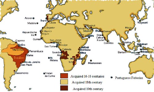 |
| Map of Portuguese possessions. |
In 1511, Alfonso, with an army of 1,100 men and 18 ships, embarked on a voyage to Malacca, then the most important and richest trading post in the Spice Islands. He conquered the region and sacked the city, building another fortress to block trade from the Pacific ocean through the Strait of Malacca. Fresh from his victories in Malacca, he put down a rebellion in Goa, and built more forts in the region.
Portugal now controlled the principal strategic points from the east coast of Africa to Malacca, with the exception of the Red Sea. A system of licenses (called cartazas) required all ships to prove that they had paid customs duties at Malacca, Goa, or Hormuz. An unlicensed ship, particularly if it belonged to Moslems, was subjected to seizure and sinking. Albuquerque's policies thus had made the Portuguese the predominant, although not the only, commercial force in the East until the 17th century
In 1513, Alfonso prepared another army of 1,400 men to capture the city of Aden (in Yemen), which offered another strategic location near the Red Sea. After a fierce two-day battle in Aden, Alfonso's army was expelled from the city. Alfonso decided to sail up the Red Sea and capture the coastal town of Jeddah, but the winds were unfavourable and he had to withdraw.
Hormuz again and Death:
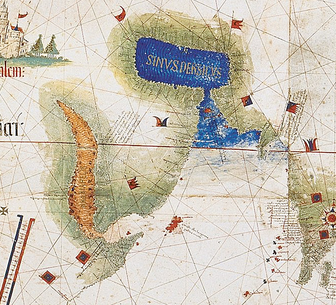 |
| Portuguese map of the Arabian Peninsula and Persian Gulf |
It was in 1521, that a fellow colleague of Alfonso, António Correia, invaded Bahrain after the local ruler refused to pay tribute (in pearls) to the Portuguese. A battle was fought in present-day Karbabad between the forces. The Portuguese conquered the island and built another fort, the Portuguese fort. Their control would last for 80 more years.
For someone with an illustrious career, his life ended on a bitter note. By this time his political enemies in Portugal had planned his demise. They convinced the king of Portugal to relieve him of his duties. Alfonso was shocked and dismayed by this treacherous cowardice, and was too old to recover from this blow. He voiced his bitterness: "I am in ill favor with the king for love of men, and with men for love of the king." He died at sea on December 16, 1515, after writing a long letter assuring the king of his loyalty
Sunday, 1 July 2012
Bahrain Pearling Trail is now a World Heritage Site!
For those of you who don't know, the United Nations Educational, Scientific and Cultural Organization (UNESCO) converged this past week (still ongoing till July 5), and just yesterday morning, they've announced that they've added two new additions to the UNESCO World Heritage List ; The Mosque of Isfahan and the Bahrain Pearling trail.
What is this trail ? A dirt road ?
Not exactly a dirt road, it's an area that consists of 17 buildings in the island of Muharraq (to the north-east of Bahrain) , three offshore oyster beds, part of the seashore and the Qal’at Bu Mahir fortress (which has, over the years, worn down to a single pillar) on the southern tip of Muharraq Island, from where boats used to set off for the oyster beds.This site was used by the many generations of pearl divers (pearl diving in Bahrain was first recorded in 2000 BC!) right until the early 1930s, when cultured Japanese pearls were introduced to the global market, effectively destroying the pearl market in Bahrain.
So what makes this so special ?
Well, UNESCO has stated that the site is:
Happy ?
For now...
What is this trail ? A dirt road ?
Not exactly a dirt road, it's an area that consists of 17 buildings in the island of Muharraq (to the north-east of Bahrain) , three offshore oyster beds, part of the seashore and the Qal’at Bu Mahir fortress (which has, over the years, worn down to a single pillar) on the southern tip of Muharraq Island, from where boats used to set off for the oyster beds.This site was used by the many generations of pearl divers (pearl diving in Bahrain was first recorded in 2000 BC!) right until the early 1930s, when cultured Japanese pearls were introduced to the global market, effectively destroying the pearl market in Bahrain.
So what makes this so special ?
Well, UNESCO has stated that the site is:
The site is the last remaining complete example of the cultural tradition of pearling and the wealth it generated at a time when the trade dominated the Gulf economy . It also constitutes an outstanding example of traditional utilization of the sea’s resources and human interaction with the environment, which shaped both the economy and cultural identity of the island’s society.Photos or it doesn't exist!
 |
| (From Herb Stovel) |
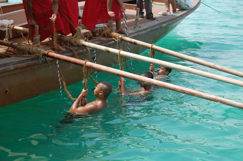 |
| Pearl divers (from Iván Rosales) |
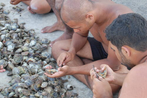 |
| Searching for pearls (from Eva Battis) |
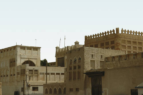 |
| Seyadi complex (from Ghassan Chemali) |
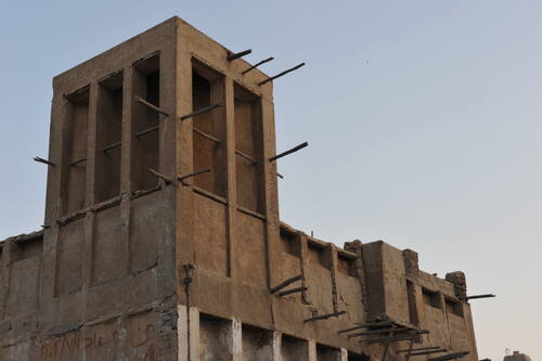 |
| Al Alawi house (from Anwar Ali Hubail) |
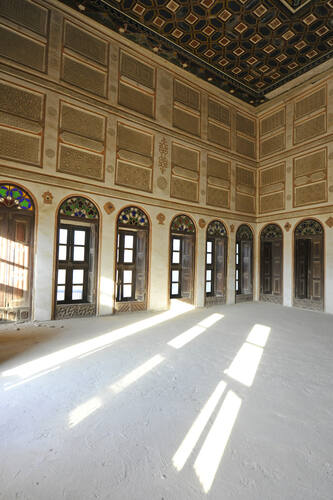 |
| Interior of Seyadi complex (from Manfred Erber) |
For now...
Subscribe to:
Posts (Atom)
The Deforestation of Nabih Saleh in Bahrain - in Maps!
This post is an example of the invaluable information and data provided by the groundbreaking people at mapBH . For those unaware, mapBH is...

-
The Ajam of Bahrain But first, an introduction. The Ajam ( عجم ) are an ethnic group in Bahrain composed of ethnic Persians who hold ...
-
 Below is a collection of stunning old photographs of Bahrain taken in the 20th century. I'll try to input as many captions as I can. Enj...
 -
The Roman Empire, at its peak The Romans were arguably history's greatest war machine. Conquering the Italian peninsula from the Lat...

