Monday 31 August 2015

A History of Archaeology in Bahrain

It was a cool winter morning in 1878 when a young British officer by the name of Edward Law Durand (5 June 1845 - 1 July 1920) swept ashore onto the island of Muharraq in Bahrain. Sent by the British Political Residency to conduct an archaeological survey (funded by the British Museum) of the island, his report of the burial mounds was the first archaeological study conducted in the country and in the Gulf since the time of Alexander (or Rome even).

Sketch of a mound from Durand's report (via Qatar Digital Library)
It was on this occasion that he thus became the first European writer to comment on the Bronze Age burial-mounds there, and had the fortune to discover a cuneiform inscription (named the Durand Stone) which he brought back to his family home in Scotland but which was later moved to London where it is believed to have been destroyed during the Blitz.

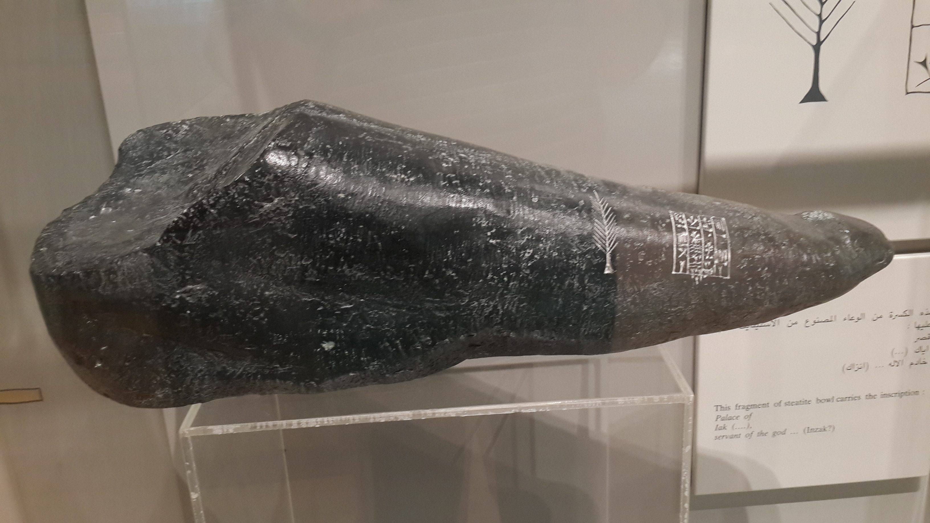
Durand's Stone is important as it contained Old Babylonian inscriptions. Only when translated by Sir Henry Rawlinson (the forefront scholar in Mesopotamian affairs) did its content become known; it spoke of a devout servant of Dilmun divinity. This quintessentially cemented the Dilmun-Bahrain hypothesis, wherein it is believed Bahrain is the location of the fabled land of Dilmun.


First, a biography of the man;
One of three sons of Sir Henry Marion Durand (1812-1871), who had served with distinction in the First Afghan War and the Indian Mutiny. Educated at Bath, Repton and Guildford; entered the 96th Regiment of Foot in 1865 but transferred to the Indian Political Service in 1868 and in 1870 was selected as ADC and Private Secretary to the Lieutenant-Governor of the Punjab. From 1871-77 he filled various posts in Rajputana and Central India, before briefly serving as Acting Political Agent in Manipur in 1877. In the following year (1878) he was appointed Acting Assistant Resident in Bushire [during which he was sent to Bahrain]. In 1881 Durand was placed in charge of the former Amir of Kabul and from 1884-86 he was Assistant Commissioner for the Afghan Boundary Commission. In 1888 he was appointed Resident in Nepal , where he served from 1889 until his retirement in 1893. He was author of 'Cyrus the Great King' (verse; London 1906), and 'Rifle, Rod, and Spear in the East' (London 1911). He died in London.
                                                                                               - The British Museum

Durand's report on the island (completed in 1879) was forwarded by Ross to A.C. Lyall, then Secretary of the Government of India's Foreign Department, and was later published in 1880 in the 'Journal of the Royal Asiatic Society' (New Series) vol. XII (Part II), pp. 189-227, where it was entitled "Extracts from Report on the Islands and Antiquities of Bahrain" (reproduced with an introduction by Michael Rice in 'Dilmun Discovered: the early years of archaeology in Bahrain', London/New York: Longman 1984, pp. 9-36).

Durand, being a fervent watercolour enthusiast, was said to have painted hundreds of watercolours of Bahrain. Unfortunately, they have been lost to history (although his watercolours from his time in India and Afghanistan exist)

Fortunately, the lovely people at the Qatar Digital Library digitised and uploaded Durand's report, so you may browse it at your leisure. I recommend you go through it, it contains rather vivid descriptions of an island long gone. I'll conclude with Durand's eloquent description of dawn after a particularly sleepless night.


References:

Monday 17 August 2015

Why do we smile in photos?

Ever noticed how no matter when or where a photograph was taken in the 19th century, it was incredibly rare to come across a single smile. Surely they can't have been that gloomy back in the day (must've been all that evil smallpox and what not) , right?

Except for that smiling guy in the other post.

But hey, let's figure out WHY our long-gone 19th century colleagues seem to be so cranky. This is by no means a complete list but rather the logical assumptions.

(Source)

1. Primitive cameras with long exposure times 

Whereas we live in an age where we capture that split fraction of a second in time and send it to our colleagues on Snapchat or Twitter (or God-forbid MySpace), our deceased colleagues weren't as fortunate. Cameras were sturdy things, they had incredibly long exposure times often requiring people to stay rather still for several minutes or else the photograph would blur out. In case you haven't tried it, smiling for several minutes whilst remaining still (like you would if you won a lottery) is incredibly hard to pull off unless you're a masochist and love some serious muscle aches. 
  

2. They were expensive and you don't want to look stupid when applying for that one job

 Who knew our rotting colleagues had so much in common with us?  Getting the opportunity to have your picture taken was serious business. These photographs were basically a permanent profile picture that was carried around their whole life. As a result, it was taken very seriously and people strived to look as passive-aggressive as humanely possible.  
Mark Twain's attitude basically sums it up;
A photograph is a most important document, and there is nothing more damning to go down to posterity than a silly, foolish smile caught and fixed forever. 
It's also worth noting that the influence the art world of portraits had on the early use of photography.  Nicholas Jeeves commented, "Smiling in paintings was only seen in the 17th century in Europe, it was a well-established fact that the only people who smiled broadly, in life and in art, were the poor, the lewd, the drunk, the innocent, and the entertainment."

3. People had terrible dental hygiene

This really doesn't need any further elaboration. 

But why do we smile?

We're silly creatures, who knows why? 

Monday 10 August 2015

The Gazetteer of the Persian Gulf, Oman and Central Arabia


The Gazetteer of the Persian Gulf, Oman and Central Arabia (nicknamed Lorimer) [2] is a two-volume encyclopedia compiled by John Gordon Lorimer. Published in secrecy by the British Raj government in 1908 and 1915, it served as a handbook for British diplomats in the Arabian Peninsula and Persia.[1]    

Declassified in 1955 under the fifty-year rule, it was widely praised for its extensive details of the region's history and geography.[2] It is considered to be "the most important single source of historical material on the Gulf States and Saudi Arabia" from the 17th to early 20th century.

History:

At the turn of the 20th century, the British empire sought to solidify its links to British-controlled India which in turn resulted in a greater interest in the Persian Gulf region, culminating in the visit of the Viceroy of India Lord Curzon to the Gulf in 1903. [1] To ensure that British agents in the region were adequately informed and prepared to strengthen their influence in the region, a convenient and portable handbook was needed. [3] 

The British Raj commissioned John Gordon Lorimer, a member of the Indian Civil Service serving in the North-West Frontier Province, to compile such a document in November 1903. Initially given six months to complete the task, Lorimer repeatedly insisted on being granted more time to ensure the work was completed thoroughly. Placed under special duty and with a team of researchers, over the next 10 years, data was collated from government archives in Calcutta and Bombay, and from multiple field expeditions to the Gulf.

The Gazatteer itself:

The gazetteer is a 5000 page document divided into two volumes; the first details the region's history and the second details its geography.[1] The geography portion of the gazetteer was completed first and was published in 1908. The history portion of the gazetteer was only completed and published in 1915, a year after Lorimer himself died in a shooting accident. 

History:

Entitled 'History, geography and geneaology', the volume was split off into three sections which were divided by ethnicity. Section 1 (the Arab section) was dedicated to the history of the Persian Gulf, central Arabia and Ottoman Iraq. Section 2 (the Persian section) regarded the history of Persia with particular interest to the predominately-Arab populated region of Arabistan. Section 3 consisted of 19 genealogical trees of the ruling families in the region. [4] 

Its research was compiled from Lorimer's own notes and colleagues such as J.A. Saldanha and C.H. Gabriel and covered various periods ranging the 17th to 20th centuries. [1] 

Geography:

Entitled the 'Geographical and Statistical' section, it is a 2000 page document and lists an extensive alphabetical arrangement of tribes, towns and villages across the region, divided into different countries.[4] 

This data was obtained through field trips and surveys conducted by Lorimer and his team.[1] Also in the volume are 56 reproduced images of the region taken from colonial records and two maps showing the distribution of pearling sites and the overall political geography.

Legacy:
Map of the Persian Gulf, Oman and Central Arabia, compiled by Hunter  (IOR/L/PS/20/C91/6, f. 1r)
 Classified for official use only, it was published in secrecy in 1908 and 1915 respectively with only dozens of copies in circulation. As such, there was no public awareness of the existence of such a document. Consequently, Lorimer's obituary makes no mention of his extensive encyclopedia.[2] Only when declassified in 1955 was he officially credited. [5]  

In 1971, The Times Literary Supplement praised the document, regarding its historical coverage as "stupendous" and its geographical section as "without modern substitute". The gazetteer, relying on British sources and written from a British viewpoint, is regarded as a valuable resource in researching the history of the Gulf. [1]  

The gazetteer in its entirety was digitised and uploaded online by the Qatar Digital Library in January 2015.[5]

Further reading and references:


Lowe, Daniel A. "‘Persian Gulf Tragedy’: the Death and Legacy of John Gordon Lorimer". Qatar Digital Library. Retrieved 10 August 2015. 

Leech, Nick (7 January 2012). "A reference book for every historian to rely on". The National. 

Lowe, Daniel. "Colonial Knowledge: Lorimer’s Gazetteer of the Persian Gulf, Oman and Central Arabia". Qatar Digital Library. Retrieved 10 August 2015.

 Lowe, Daniel (6 December 2014). "The diplomat’s portable handbook (wheelbarrow required)". BBC News. Retrieved 10 August 2015. 

Author's note: the above was previously posted onto Wikipedia first. 

Why More Maps Should Be Upside Down

If you've utilised a map at any point in your life, whether it's Google Maps to find out which right turn you just missed on the hig...